
“It’s a place where one can see how nature shapes human endeavors in the American West and where distance and aridity have been pitted against our dreams and courage.” President Bill Clinton

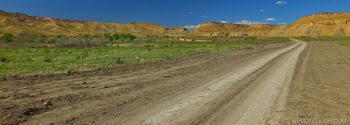
Twenty-five miles west of Glen Canyon Dam, lies a former power line maintenance road known as Cottonwood Canyon. Redesignated as a scenic byway, this forty-six mile, unpaved road, connects Highway 89 with Utah State Route 12. Considered to be an adventurer’s thoroughfare, Cottonwood Canyon traverses an ancient inland sea bed, delivering road-trippers into the inner sanctum of Grand StairCase Escalante National Monument.

Impassable When Wet! The sign does not lie or exaggerate. After a rainstorm, the road’s bentonite clay base transforms itself into a muddy, slick, slip and slide. Avoid this drive during the monsoon season and be sure to contact the Big Water Visitor Center for the latest road conditions and weather updates. Cell phone service across the Monument is non-existent. This is not an area to experience car problems or to get bogged in the mud. To quote the Monument’s website, “Grand Staircase-Escalante can be a fierce and dangerous land, and its wild character should not be underestimated.”
DAY ONE
With clear road conditions and a favorable weather forecast, the Perfect Stranger, Shadow, and I left the southern terminus of Cottonwood Canyon road.
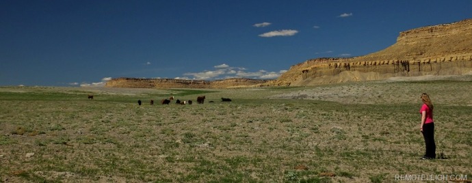
Less than five miles into our trip, we were greeted by grazing livestock, lush green grass, and dramatic rock formations. It’s not uncommon to see cattle grazing on public lands managed by the BLM (Bureau Of Land Management) and the Forest Service. Local ranchers pay a monthly fee of two dollars per head in order for their cattle to roam free on public lands.

As crazy as it may sound, I envied the cattle. After spending a year in Northern Arizona, I stopped taking Mother Nature’s carpet for granted. Grass was to be celebrated, appreciated, and enjoyed! I had become so accustomed to walking on sandstone, mud, and gravel, that grass now felt like memory foam underfoot.


For the first seven miles, Cottonwood Canyon Road runs parallel to the silty, murky, and muddy Paria River. Carrying the highest sediment concentration in the United States, the Paria packs two pounds of mud per quart of water. Critical to the health and welfare of the Grand Canyon’s riparian ecosystem, the Paria River is responsible for delivering silt and sediment into the Colorado River.

Besides its sediment value, the Paria River holds a special place in my heart. Measuring almost one hundred miles in length, I’ve been fortunate enough to have hiked almost half of this desert beauty. I celebrated my 40th birthday backpacking the Paria and have spent countless hours hiking, swimming, mud bathing and exploring the river’s numerous side canyons.


")


At some point, I will thru-hike the Paria. Not only as a token of my appreciation but as a way to say thank you for all the memories and life lessons the river has afforded me. The Paria has influenced and impacted my life, and now the Perfect Stranger, Shadow, and I get to share the river together.

Driving deeper into the canyon, the potholes and ruts quickly reduced our speed to a mere ten miles an hour. Without a four-wheel drive or high clearance vehicle, we decided to err on the side of caution.

On a positive note, identifying potential rock scrambling areas becomes easier when driving at slower speeds.

The Perfect Stranger quickly discovered her roadside ceiling to the sky and within minutes was headed for the moon.

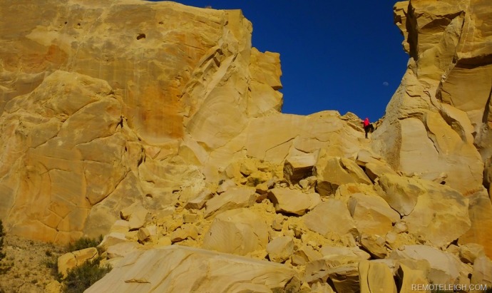
At mile twenty-five, we officially entered “Candyland.” Surrounded by red, white, and pink jagged pinnacles, these multi-colored rocks formed a serrated ridge, at a forty-five-degree angle.


Out of this world and unlike anything we had ever seen, we decided to make Candyland our base camp for the night.

At an elevation of 5700ft, our tent was perched on a hillside summit overlooking a geological masterpiece. With no other campers in sight, Candyland was exclusively ours until morning.
DAY TWO
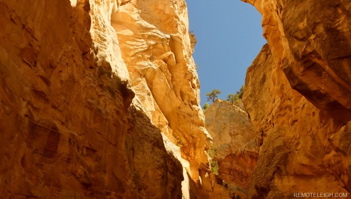
After a late morning breakfast, the Perfect Stranger, Shadow, and I drove down to the Cottonwood Narrows trailhead. Located in the belly of Candyland, “The Narrows”, is an easy three-mile loop hike.


Looking more like a geisha than a day hiker, I applied some last-minute sunscreen before we crossed the road and descended into the canyon.

Bookended by walls of Navajo Sandstone, the canyon felt like a time vault that permitted visitors for the day. Bearing the battle wounds from a million years worth of erosion, wind, and water, “The Narrows” was unashamedly beautiful.

The intricate dance of sunlight and shadows lured us deeper into the canyon. Unbelievably, we were the only hikers on trail; yet, this was the very inspiration for our offseason and off the beaten path travel. Having never been a fan of tour buses and densely populated national parks, I have found solitude by exploring backcountry roads, national monuments, and state parks.


Greeted by a large slice of blue sky, we grabbed some final shots of the canyon walls before exiting the trail.

With only a few hours left before sunset, we decided to continue our exploration of Cottonwood Canyon road.

The rest of the day was considered to be a fact-finding mission for a future return trip. Twenty-five miles away was Kodachrome State Park. Having never visited the park before, I was hoping to get a sneak peek before dark.

I first heard about this park in 1989, while living in Japan. A colleague of mine worked for Fuji Film and had visited the park in the late 1970’s. One night after dinner, my friend Nakamoto shared a photo album from his trip to Southern Utah. His black and white pictures from Kodachrome were beyond stunning. Nakamoto repeatedly told me that if I ever journeyed to America, I must visit Kodachrome State Park.

Our next stop was Grosvenor Arch.

Standing one hundred and fifty-two feet high and spanning ninety-two feet wide, Grosvenor is a massive sandstone double arch and worthy of an overnight visit. I could only imagine the light show over this magical formation in the early morning and late evening.

With less than fifteen miles to Kodachrome State Park, the terrain appeared wild, vast, and open. Parked at the top at of a hill, we peered down into mother nature’s amphitheater. Was this a teaser for Kodachrome or was it simply the planet presenting a united front of strength and vulnerability?

Greeted by cows at Kodachrome’s entrance, we followed a gravel road leading deeper into the park.


Representing one hundred and eighty million years of geologic time, Kodachrome’s monolithic spires and sandstone layers inspired a National Geographic Society’s team to name the area after Kodak’s popular color film. Seventy years later, I find myself driving to the tallest spire in the park, Chimney Rock.

With the sun setting, I was glad the Perfect Stranger, Shadow, and I were able to spend the final light hours in Kodachrome State Park.

Feeling slightly disappointed that our time at Kodachrome was ever so brief, I quickly reminded myself that a return visit was on the horizon. It seemed our two days exploring Cottonwood Canyon Road barely scratched the surface of what this forty mile long fold in the earth has to offer.

Wow! Cottonwood Canyon seems so astonishing and exceptional. I haven’t explored this area but it seems definitely worth seeing. Thanks for the inspiring post!
LikeLiked by 1 person
Thank you! It’s definitely a must see and visit.
LikeLike
Wow this looks absolutely awesome! There are still so many incredible parts of the states I need to explore!
LikeLiked by 1 person
Yes, I agree! So many amazing places to explore.
LikeLike
I am getting ready to take a US roadtrip and hadn’t considered Cottonwood. I think I might have to add it to the list. It looks like an amazing time!
LikeLiked by 1 person
It’s an amazing drive and a guaranteed way to escape Utah’s Big 5 crowds. Let me know if you head that way, I can give you some other suggestions for the area as well.
LikeLike
I love this area so much. Didn’t know thru hiking Paria was a thing! Will have to search that out.
LikeLike
Yes, one of my favorite areas. Thru-hiking the Paria isn’t a thing yet, just a dream of mine. I have hiked Wirepass to Lees Ferry, simply stunning!
LikeLike
I have traveled a lot in this area. So beautiful! Thank you for sharing your adventures.
LikeLike
Thank you! Having lived in the area for a few years, I still didn’t get to explore and experience everything on my list. Hope to go back and thru-hike the Paria.
LikeLiked by 1 person